Property Record
1909 Unknown, Melbourne, FL 32904
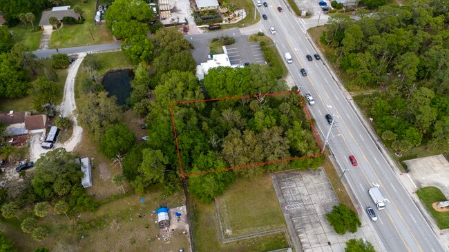
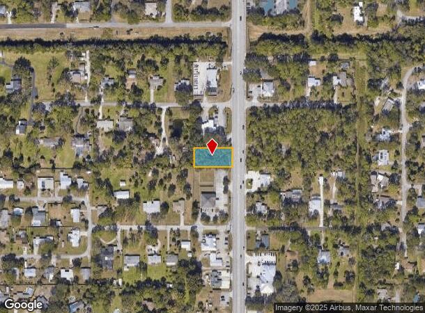
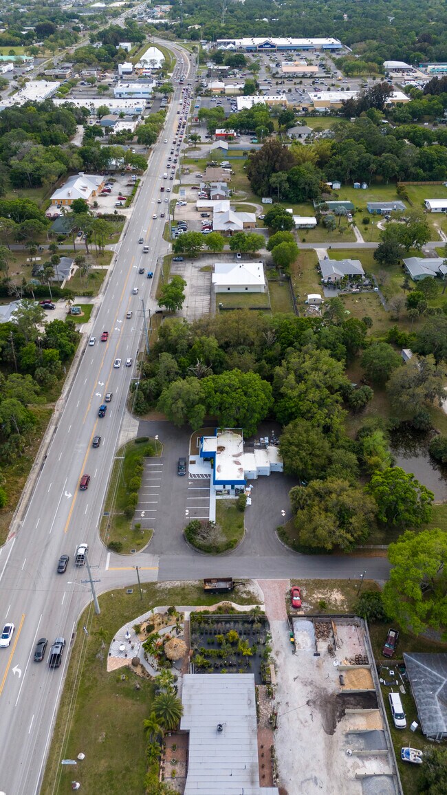
This Property Is For Sale
NEARBY LISTINGS FOR SALE OR LEASE
-
-
-
Minton Rd & Heritage Oaks blvd
West Melbourne, FL 32904
$600,000 - $3,500,000
0.53 - 2.28 AC Lot
Land
-
-
-
-
-
-
-
-
-
-
-
-
-
-
-
-
View all Melbourne listings for sale on LoopNet.com
Property Detail
1909 Unknown
Palm Bay-Melbourne-Titusville, FL
L S T Estates
28-36-01-01-00000.0-000E.28
L S T ESTATES LOT E 28 & S 15 FT OF LOT E 29 EXC RD R/W
Commercialacreage
Brevard
X
Florida
12009C0583G
e
2024
0.48 AC
2025
Brevard County
064601
Orlando
DEMOGRAPHICS near 1909 Unknown
1 Mile
3 Mile
5 Mile
2024 Total Population
4,721
48,652
136,298
2029 Population
5,153
53,269
149,133
Pop Growth 2024-2029
+ 9.15%
+ 9.49%
+ 9.42%
Average Age
45
43
43
2024 Total Households
2,015
19,745
57,404
HH Growth 2024-2029
+ 8.88%
+ 9.34%
+ 9.27%
Median Household Inc
$74,236
$69,629
$58,999
Avg Household Size
2.20
2.30
2.30
2024 Avg HH Vehicles
2.00
2.00
2.00
Median Home Value
$282,425
$253,751
$236,863
Median Year Built
1978
1984
1985
Nearby Places
Map Layers
Map Styles
 Street
 Aerial
- Restaurants
- Banks
- Shops
- Fitness
- Groceries
PUBLIC TRANSPORTATION
AIRPORT
Melbourne Orlando International
DRIVE
WALK
Distance
Melbourne Orlando International
11 min
4.1 mi
Freight Ports
Port Canaveral
DRIVE
WALK
Distance
Port Canaveral
47 min
36.7 mi
Nearby Properties
Address
Land Use
TOTAL SIZE
Lot Size
Zoning
Address
Land Use
TOTAL SIZE
Lot Size
Zoning
433,669 SF
21.22 AC
AU
Address
Land Use
TOTAL SIZE
Lot Size
Zoning
506,643 SF
80 AC
RA
Address
Land Use
TOTAL SIZE
Lot Size
Zoning
380,944 SF
32.18 AC
RA
Address
Land Use
TOTAL SIZE
Lot Size
Zoning
391,740 SF
30 AC
Address
Land Use
TOTAL SIZE
Lot Size
Zoning
425,167 SF
43.33 AC
Address
Land Use
TOTAL SIZE
Lot Size
Zoning
475,791 SF
229.02 AC
M1
Address
Land Use
TOTAL SIZE
Lot Size
Zoning
265,272 SF
21.17 AC
M1
Address
Land Use
TOTAL SIZE
Lot Size
Zoning
265,062 SF
14.75 AC
M1
Address
Land Use
TOTAL SIZE
Lot Size
Zoning
384,430 SF
33.07 AC
R2
Address
Land Use
TOTAL SIZE
Lot Size
Zoning
389,175 SF
12.18 AC
Address
Land Use
TOTAL SIZE
Lot Size
Zoning
387,843 SF
27.19 AC
R3
Address
Land Use
TOTAL SIZE
Lot Size
Zoning
197,734 SF
27.99 AC
M1
Address
Land Use
TOTAL SIZE
Lot Size
Zoning
297,886 SF
32.38 AC
C-1
Address
Land Use
TOTAL SIZE
Lot Size
Zoning
261,552 SF
23.21 AC
R2
Address
Land Use
TOTAL SIZE
Lot Size
Zoning
268,487 SF
20.08 AC
RA
Address
Land Use
TOTAL SIZE
Lot Size
Zoning
280,518 SF
13.88 AC
Address
Land Use
TOTAL SIZE
Lot Size
Zoning
295,347 SF
14.61 AC
R2
Address
Land Use
TOTAL SIZE
Lot Size
Zoning
542,262 SF
51.88 AC
CP
Address
Land Use
TOTAL SIZE
Lot Size
Zoning
201,325 SF
11.41 AC
Address
Land Use
TOTAL SIZE
Lot Size
Zoning
226,121 SF
17.73 AC
Address
Land Use
TOTAL SIZE
Lot Size
Zoning
225,020 SF
24.25 AC
Address
Land Use
TOTAL SIZE
Lot Size
Zoning
74,716 SF
366.45 AC
M1
Address
Land Use
TOTAL SIZE
Lot Size
Zoning
196,130 SF
16 AC
Address
Land Use
TOTAL SIZE
Lot Size
Zoning
182,494 SF
8.53 AC
CCP
Address
Land Use
TOTAL SIZE
Lot Size
Zoning
139,968 SF
23.46 AC
CRA
Address
Land Use
TOTAL SIZE
Lot Size
Zoning
205,564 SF
14.56 AC
M1
Address
Land Use
TOTAL SIZE
Lot Size
Zoning
198,876 SF
64.32 AC
M1
Address
Land Use
TOTAL SIZE
Lot Size
Zoning
175,610 SF
10.01 AC
CCP(15)
Address
Land Use
TOTAL SIZE
Lot Size
Zoning
146,527 SF
42.12 AC
M-1
Address
Land Use
TOTAL SIZE
Lot Size
Zoning
248,019 SF
12.22 AC
P1
The World's #1 Commercial Real Estate Marketplace
Connect with us
© 2025 CoStar Group
The information above has been obtained from sources believed reliable. While we do not doubt its accuracy we have not verified it and make no guarantee, warranty or representation about it. It is your responsibility to independently confirm its accuracy and completeness. Any projections, opinions, assumptions, or estimates used are for example only and do not represent the current or future performance of the property. The value of this transaction to you depends on tax and other factors which should be evaluated by your tax, financial, and legal advisors. You and your advisors should conduct a careful, independent investigation of the property to determine to your satisfaction the suitability of the property for your needs.